Uncategorized files
Jump to navigation
Jump to search
Showing below up to 250 results in range #551 to #800.
View (previous 250 | next 250) (20 | 50 | 100 | 250 | 500)
 ExportKmzGarminCustomMapsTiles.png 200 × 17; 690 bytes
 ExportOimAjaxError0.png 240 × 144; 1 KB
 ExportPdfExampleCMYK.png 262 × 324; 9 KB
 ExportPdfExampleColorTable.png 912 × 169; 13 KB
 ExportPdfExampleNormalView.png 369 × 456; 7 KB
 ExportPdfExampleSpotColorView.png 369 × 456; 7 KB
 ExportPdfExampleSpotColorsBlack.png 265 × 327; 7 KB
 ExportPdfExampleSpotColorsBlue.png 264 × 324; 3 KB
 ExportPdfExampleSpotColorsCombinded.png 1,051 × 678; 89 KB
 ExportPdfExampleSpotColorsCombindedAcrobatReader1.png 457 × 565; 27 KB
 ExportPdfExampleSpotColorsCombindedAcrobatReader2.png 1,034 × 679; 50 KB
 ExportPdfExampleSpotColorsCombindedAcrobatReader3.png 457 × 565; 34 KB
 ExportPdfExampleSpotColorsGreen.png 263 × 325; 4 KB
 ExportPdfExampleSpotColorsYellow.png 265 × 326; 2 KB
 ExportRelayDialog.PNG 423 × 414; 25 KB
 Export Courses KMZ.PNG 1,921 × 994; 2.69 MB
 ExportedCourse.PNG 706 × 586; 119 KB
 ExtractCliffFeatures.png 650 × 364; 160 KB
 ExtractCliffFeatures2.png 650 × 369; 267 KB
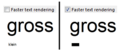 FasterTextRendering.PNG 297 × 129; 6 KB
 FileErrorMessageOCAD11BetaInstallation.png 478 × 171; 18 KB
 FileFolderPuzzleO.PNG 296 × 281; 7 KB
 Fill.gif 724 × 416; 957 KB
 FillBoundedArea.gif 637 × 404; 1.89 MB
 FillBoundedAreasLimits.png 340 × 208; 29 KB
 FillTool.PNG 28 × 28; 590 bytes
 FilledCircleTool.PNG 28 × 28; 507 bytes
 FilledRectangleTool.PNG 28 × 28; 394 bytes
 FindObjectDialog.PNG 340 × 174; 16 KB
 FindSelectedObjects.gif 824 × 584; 933 KB
 FindUTMZone.PNG 338 × 219; 20 KB
 Find Objects.gif 570 × 512; 2.81 MB
 Finnland.gif 22 × 15; 892 bytes
 FirstAidPoint.png 24 × 24; 168 bytes
 FirstAidPoint Example.png 200 × 120; 34 KB
 FirstFreeCode.png 24 × 24; 218 bytes
 Firstpoint.GIF 14 × 13; 845 bytes
 Following Existing Objects.gif 826 × 582; 6.03 MB
 Framecol.gif 194 × 53; 1 KB
 FramingModeLine.PNG 609 × 117; 9 KB
 FramingModeOff.PNG 609 × 62; 4 KB
 FramingModeShadow.PNG 609 × 70; 7 KB
 Frankreich.gif 22 × 15; 902 bytes
 FreehandModeforTablet.png 600 × 400; 225 KB
 Freehand ExportPDF Settings.gif 251 × 427; 8 KB
 Freehand To Curve.PNG 416 × 198; 9 KB
 FullLine.PNG 624 × 39; 2 KB
 FullLine MainLine.PNG 473 × 448; 26 KB
 FullStopHelp.PNG 608 × 342; 14 KB
 Fullline.gif 289 × 13; 936 bytes
 FunnelTapes.png 77 × 19; 683 bytes
 FunnelTapesExample.png 236 × 46; 5 KB
 GIS AddTextsByRecords.PNG 505 × 403; 25 KB
 GIS AssignSymbolByRecords.PNG 442 × 422; 27 KB
 GIS ImportShapeFiles.PNG 463 × 713; 40 KB
 GIS Symbolsset.PNG 1,073 × 808; 60 KB
 GPS Orienteering Logo.png 72 × 72; 6 KB
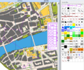
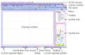 GUI.JPG 1,402 × 912; 249 KB
 GeneralizeBuildings.PNG 520 × 502; 22 KB
 GenerateMapPreview.PNG 23 × 23; 3 KB
 GenerateQrCode.png 544 × 371; 13 KB
 GenerateQrCodeExample.png 580 × 300; 61 KB
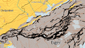
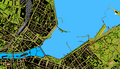 Geneva.png 700 × 400; 216 KB
 GeoPackageImport1.png 656 × 268; 10 KB
 GeoPackageImport2.png 662 × 296; 11 KB
 GeoPackageImport3.png 824 × 255; 8 KB
 Geolog.gif 296 × 48; 1 KB
 GeologicalLine.PNG 625 × 89; 5 KB
 GeologicalLine Decrease.PNG 471 × 452; 21 KB
 GeologicalLine Distances.PNG 476 × 447; 25 KB
 GeologicalLine SymbolEditorA.PNG 398 × 399; 10 KB
 GeologicalLine SymbolEditorB.PNG 401 × 398; 10 KB
 GeologicalLine Symbols.PNG 470 × 450; 25 KB
 GeoreferencedNonGeoreferencedMap.png 866 × 246; 445 KB
 GetObjects.PNG 876 × 675; 280 KB
 GetObjectsFromCurrentView.PNG 23 × 23; 3 KB
 GhostscriptFilePath.png 597 × 251; 8 KB
 GhostscriptFilePathNew.png 386 × 57; 2 KB
 GoogleMapsLayers.png 787 × 229; 298 KB
 GoogleMapsUncheckLabels.png 812 × 218; 225 KB
 GoogleStreetView.jpg 754 × 659; 175 KB
 GoogleStreetViewDragDirection.png 293 × 373; 31 KB
 GpsInterfaceLocationApi.png 405 × 111; 6 KB
 GpsRealTimeShowTail.png 573 × 279; 15 KB
 GpsRealTimeThickerCursor.png 627 × 382; 19 KB
 GpsViaSmartphone.png 177 × 233; 18 KB
 Gradient.PNG 417 × 210; 15 KB
 Graphicmodifications.gif 700 × 500; 1.14 MB
 Grossbritanien.gif 22 × 11; 1 KB
 GroupUngroup.png 447 × 134; 8 KB
 HTTP.png 397 × 114; 5 KB
 Hatch.PNG 417 × 379; 30 KB
 HatchAreas.PNG 1,068 × 814; 121 KB
 HatchAreasExample.PNG 1,024 × 125; 140 KB
 HatchExample.PNG 756 × 167; 6 KB
 HatchTip.PNG 533 × 321; 13 KB
 HeighOnASlope.PNG 109 × 67; 987 bytes
 Help.gif 763 × 429; 24 KB
 Highway.PNG 808 × 135; 8 KB
 Highway DoubleLine.PNG 478 × 452; 24 KB
 Highway Framing.PNG 476 × 446; 19 KB
 Highway MainLine.PNG 478 × 457; 20 KB
 HillShading.PNG 778 × 778; 781 KB
 HillShading2.PNG 682 × 682; 397 KB
 HillShadingPreview.PNG 653 × 373; 136 KB
 HillShading multidirectional.png 851 × 528; 446 KB
 Hint.jpg 20 × 20; 15 KB
 HoleWithOnlyTwoVertices.PNG 239 × 183; 3 KB
 HowTos.gif 465 × 360; 48 KB
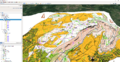
 Hundschopf.png 700 × 400; 116 KB
 HypsometricMap.PNG 469 × 472; 154 KB
 IOrienteering Logo.png 500 × 479; 104 KB
 ISMTBOM2021CourseSetting.png 392 × 93; 3 KB
 ISMTBOM2021 CS.png 394 × 71; 3 KB
 ISOM 2017 Comparison.png 803 × 786; 97 KB
 ISOM 2017 Comparison 15000.png 900 × 770; 161 KB
 ISSkiOM 2019 CS.png 395 × 95; 4 KB
 IconDistributeObjects Horizontal.PNG 26 × 26; 307 bytes
 IconDistributeObjects Vertical.PNG 26 × 26; 286 bytes
 IconEditor.JPG 490 × 383; 75 KB
 IconFillBoundedAreaMode.png 23 × 23; 823 bytes
 IconGSV.PNG 16 × 16; 224 bytes
 IconSketchMode.png 23 × 23; 371 bytes
 IconSmooth.PNG 24 × 24; 344 bytes
 Icon AccuracyCircle.PNG 22 × 22; 344 bytes
 Icon AddGPSPositionToCalculateAverage.PNG 22 × 22; 384 bytes
 Icon AlignObjectsHorizontal.PNG 23 × 23; 3 KB
 Icon AlignObjectsHorizontalCoordinateCentered.PNG 27 × 26; 266 bytes
 Icon AlignObjectsVertical.PNG 23 × 23; 3 KB
 Icon AutomaticJoining.PNG 23 × 23; 4 KB
 Icon BackgroundMapManager.PNG 18 × 18; 465 bytes
 Icon CSA Redo.PNG 22 × 22; 474 bytes
 Icon CSA Undo.PNG 22 × 22; 479 bytes
 Icon ChangeSymbolForAllObjectsWithThisSymbol.PNG 23 × 23; 4 KB
 Icon ChangeSymbolOfObject.PNG 23 × 23; 4 KB
 Icon ChangeToBezierCurve.PNG 23 × 23; 4 KB
 Icon ChangeToPolyline.png 23 × 23; 3 KB
 Icon CheckIn.PNG 25 × 25; 446 bytes
 Icon CheckOut.PNG 28 × 28; 409 bytes
 Icon CircleMode.PNG 23 × 23; 4 KB
 Icon ConnectDisconnect.PNG 22 × 22; 363 bytes
 Icon ConvertToGraphicObject.PNG 23 × 23; 4 KB
 Icon CornerVertex.PNG 23 × 23; 4 KB
 Icon Crop.PNG 18 × 18; 518 bytes
 Icon CurveMode.PNG 23 × 23; 4 KB
 Icon Cut.PNG 23 × 23; 4 KB
 Icon CutArea.PNG 23 × 23; 4 KB
 Icon CutHole.PNG 23 × 23; 4 KB
 Icon DashVertex.PNG 23 × 23; 4 KB
 Icon Delete.PNG 23 × 23; 4 KB
 Icon Delete2.PNG 23 × 24; 463 bytes
 Icon DeleteObjectsInDatabase.PNG 22 × 22; 310 bytes
 Icon DistributeObjectsHorizontalCoordinate.PNG 20 × 19; 466 bytes
 Icon DistributeObjectsVerticalCoordinate.PNG 15 × 18; 431 bytes
 Icon DoDatabaseMaintenance.PNG 22 × 22; 597 bytes
 Icon DrawingMultiplePointObjects.PNG 23 × 23; 3 KB
 Icon DuplicateObject.PNG 23 × 23; 4 KB
 Icon EllipseMode.PNG 23 × 23; 4 KB
 Icon FillOrMakeBorder.PNG 23 × 23; 4 KB
 Icon FindGPSMarker.PNG 22 × 22; 343 bytes
 Icon FindSelectedObjects.PNG 23 × 23; 4 KB
 Icon FreehandMode.PNG 23 × 23; 4 KB
 Icon GPSFilter.PNG 22 × 22; 371 bytes
 Icon GeneralizeBuildings.PNG 20 × 18; 518 bytes
 Icon GenerateMapPreview.PNG 22 × 22; 542 bytes
 Icon GetObjectsFromCurrentView.PNG 22 × 22; 592 bytes
 Icon ImportMap.PNG 22 × 22; 439 bytes
 Icon IndicateDirectionOfAreaPatternPointOrTextObject.PNG 23 × 23; 4 KB
 Icon InterpolateObjects.PNG 23 × 23; 3 KB
 Icon Join.PNG 23 × 23; 3 KB
 Icon LaserDistance.PNG 23 × 23; 3 KB
 Icon LoadObjectsFromCurrentView.PNG 34 × 22; 886 bytes
 Icon ManageServerBookmarks.PNG 22 × 22; 378 bytes
 Icon Measure.PNG 23 × 23; 4 KB
 Icon Merge.PNG 23 × 23; 4 KB
 Icon MoveDuplicatebySpecifiedDistance.PNG 20 × 19; 689 bytes
 Icon MoveParallel.PNG 23 × 23; 4 KB
 Icon New.PNG 23 × 23; 4 KB
 Icon NormalVertex.PNG 23 × 23; 4 KB
 Icon NumericMode.PNG 23 × 23; 3 KB
 Icon ObjectHistory.PNG 22 × 22; 381 bytes
 Icon ObjectInformation.PNG 17 × 20; 414 bytes
 Icon Open.PNG 23 × 23; 4 KB
 Icon OpenGoogleStreetView.PNG 24 × 24; 710 bytes
 Icon OpenRealTimeGPSSettings.PNG 22 × 22; 246 bytes
 Icon Pan.PNG 22 × 22; 4 KB
 Icon PanLocked.PNG 22 × 23; 4 KB
 Icon PauseGPSMeasurement.PNG 22 × 22; 266 bytes
 Icon Print.PNG 23 × 23; 4 KB
 Icon RectangularLineMode.PNG 23 × 23; 4 KB
 Icon RectangularMode.PNG 23 × 23; 4 KB
 Icon Redo.PNG 23 × 23; 4 KB
 Icon RemoveVertex.PNG 23 × 23; 4 KB
 Icon Reshape.PNG 23 × 23; 4 KB
 Icon ReverseObject.PNG 23 × 23; 4 KB
 Icon RightsManagement.PNG 22 × 22; 643 bytes
 Icon RotateEnterAngle.PNG 23 × 23; 3 KB
 Icon RotateObject.PNG 23 × 23; 4 KB
 Icon RotateObjectAngle.png 23 × 23; 474 bytes
 Icon Save.PNG 23 × 23; 4 KB
 Icon SaveForOfflineWork.PNG 22 × 22; 630 bytes
 Icon SelectAndEditObject.PNG 23 × 23; 3 KB
 Icon SelectDuplicateObjects.PNG 20 × 20; 505 bytes
 Icon SelectLineTextObjectswithLinetooShort.PNG 22 × 21; 435 bytes
 Icon SelectObjectAndEditVertex.PNG 23 × 23; 4 KB
 Icon SelectObjectWithLassoTool.PNG 20 × 19; 540 bytes
 Icon SelectObjectwithLassoTool.PNG 29 × 28; 358 bytes
 Icon SelectSelfIntersectedObjects.PNG 20 × 20; 482 bytes
 Icon Setup.PNG 25 × 26; 398 bytes
 Icon ShowCheckedOutObjects.PNG 22 × 22; 588 bytes
 Icon ShowEntireMap.PNG 22 × 23; 4 KB
 Icon ShowGrid.PNG 23 × 23; 3 KB
 Icon ShowProjectInformation.PNG 22 × 22; 693 bytes
 Icon ShowRulerGuides.PNG 18 × 19; 448 bytes
 Icon ShowRulers.PNG 19 × 19; 471 bytes
 Icon Smooth.PNG 23 × 23; 4 KB
 Icon Snapping.PNG 23 × 23; 4 KB
 Icon StartGPSMeasurement.PNG 22 × 22; 299 bytes
 Icon StopGPSMeasurement.PNG 22 × 22; 251 bytes
 Icon StraightLineMode.PNG 23 × 23; 3 KB
 Icon SymbolStatusManager.PNG 18 × 18; 516 bytes
 Icon Undo.PNG 23 × 23; 3 KB
 Icon ZoomIn.PNG 22 × 23; 4 KB
 Icon ZoomInLocked.PNG 22 × 23; 4 KB
 Icon ZoomOut.PNG 22 × 23; 4 KB
 Icon ZoomOutToPreviousView.PNG 22 × 23; 4 KB
 Icon ZoomToNextView.PNG 23 × 23; 3 KB
 Icon ZoomToPreviousView.PNG 22 × 23; 4 KB
 Icon ZoomtoSelectedObjects.PNG 20 × 20; 553 bytes
 IgnMapJpeg2000 1.png 1,044 × 793; 528 KB
 IgnMapJpeg2000 2.png 351 × 551; 32 KB
 ImportDxfUnsymbolized.png 569 × 487; 25 KB
 ImportFreehandXml.PNG 476 × 276; 12 KB
 ImportMapDialog.PNG 337 × 283; 19 KB
 ImportMap BlendMode NoCut.png 580 × 300; 88 KB
 ImportMap NoBlendMode NoCut.png 580 × 300; 69 KB
 ImportMaps.PNG 23 × 23; 3 KB
 ImportOCADMap.png 461 × 619; 29 KB
 ImportOcadMap.png 461 × 614; 16 KB
 ImportShapeFile.PNG 710 × 580; 38 KB
 ImportShapeFileOrienteering.PNG 710 × 388; 29 KB
 ImportShapeFileOrienteeringDatabaseTable.PNG 777 × 230; 16 KB
 ImportShapeFileOrienteeringViewTable.PNG 21 × 21; 262 bytes
 ImportShapeText1.png 841 × 561; 78 KB
 ImportShapeText2.png 491 × 387; 22 KB
 ImportShapeText3.png 841 × 561; 79 KB
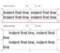 IndentFirstLine.PNG 424 × 373; 27 KB
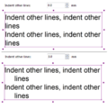 IndentOtherLines.PNG 397 × 396; 29 KB
 Index1.gif 120 × 120; 10 KB
 Index2.gif 120 × 120; 12 KB


