Routing: Difference between revisions
No edit summary |
|||
| (22 intermediate revisions by 4 users not shown) | |||
| Line 1: | Line 1: | ||
[[File:Pro40px.PNG|This function is available in OCAD Professional.|link=https://www.ocad.com/en/products/ocad-for-cartography]] | |||
This command is only available if the map is georeferenced and a '''[[Create_a_New_Map#Set_Scale_and_Coordinate_System|Coordinate System]]''' is set.<br /> | |||
This command can be used to find the fastest way by car between two arbitrary points by downloading and importing the vector data from Google Maps. | This command can be used to find the fastest way by car between two arbitrary points by downloading and importing the vector data from Google Maps. | ||
<br /> | <br /> | ||
=== Routing by Entering a Location === | === Routing by Entering a Location === | ||
| Line 7: | Line 10: | ||
2. Enter the name of the start and end location.<br /> | 2. Enter the name of the start and end location.<br /> | ||
[[File:Routing1.png|none|500px]]<br /> | [[File:Routing1.png|none|500px]]<br /> | ||
=== Routing by Entering Coordinates === | === Routing by Entering Coordinates === | ||
| Line 23: | Line 17: | ||
3. Do the same for the end location.<br /> | 3. Do the same for the end location.<br /> | ||
[[File:Routing6.png|none|500px]]<br /> | [[File:Routing6.png|none|500px]]<br /> | ||
<br /> | <br /> | ||
[[File:Hint.jpg|hint]] Please note that the function '''Get and import KML file''' does not work anymore. | |||
=== Show | === Show Route in Google Maps === | ||
Click on the '''Open in Google Maps''' button | Click on the '''Open in Google Maps''' button to see the route on Google Maps. <br /> | ||
[[File:Routing5.png|none|500px]]<br /> | [[File:Routing5.png|none|500px]]<br /> | ||
=== Template File === | === Template File === | ||
The | The symbols and colors used for routing are saved in a template file (usually ''C:\Program Files\OCAD\OCAD 20xx\Templates\Template Routing.ocd'') and can be edited there, too. <br /> | ||
[[File:Routing9.png|400px]] <br /> | |||
Latest revision as of 10:37, 31 January 2019
This command is only available if the map is georeferenced and a Coordinate System is set.
This command can be used to find the fastest way by car between two arbitrary points by downloading and importing the vector data from Google Maps.
Routing by Entering a Location
1. Select Routing in the Map menu to open the Routing dialog.
2. Enter the name of the start and end location.
Routing by Entering Coordinates
Instead of entering the name of the start and end point you can also simply click on these locations on the map.
1. Activate the Coordinate option in the Routing dialog.
2. Click on the Get Coordinate from Drawing Area button ![]() , then click on the start location on your map. OCAD displays the coordinate in the Routing dialog. Optionally you can enter the coordinate manually.
, then click on the start location on your map. OCAD displays the coordinate in the Routing dialog. Optionally you can enter the coordinate manually.
3. Do the same for the end location.
![]() Please note that the function Get and import KML file does not work anymore.
Please note that the function Get and import KML file does not work anymore.
Show Route in Google Maps
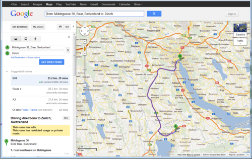
Click on the Open in Google Maps button to see the route on Google Maps.
Template File
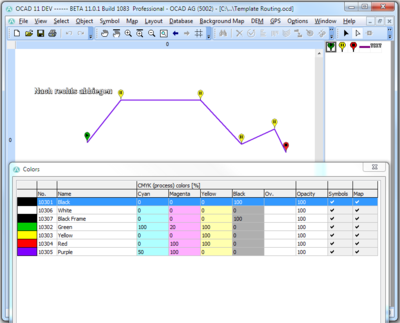
The symbols and colors used for routing are saved in a template file (usually C:\Program Files\OCAD\OCAD 20xx\Templates\Template Routing.ocd) and can be edited there, too.


