Online Map Services: Difference between revisions
No edit summary |
|||
| (9 intermediate revisions by 3 users not shown) | |||
| Line 1: | Line 1: | ||
[[File:Mas40px.PNG|This function is available in OCAD Mapping Solution.|link=https://www.ocad.com/en/products/ocad-for-cartography]][[File:Ori40px.PNG|This function is available in OCAD Orienteering.|link=https://www.ocad.com/en/products/ocad-for-orienteering]][[File:Sta40px.PNG|This function is available in OCAD Starter.|link=https://www.ocad.com/en/products/ocad-for-orienteering]] | |||
[[File:Hint.jpg|hint]] This function does not work on some computers with 32-bit version of OCAD! | |||
[[ | Choose this command from the '''[[Background Map|Background Map]]''' menu to load a screenshot from a Online Map Service as background map. | ||
--> Short '''[https://youtu.be/ZEU79Xvx_-4 Video on YouTube]''' | |||
[[File:OnlineMapServices.png|600px]] | |||
==Define an extent== | |||
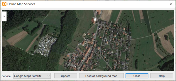
Click ''' | Click on the '''Update''' button to move to Online Map Service to the center of the drawing area. | ||
Move and zoom until the Online Map Service has the desired extent. You can also enlarge the Online Map Services dialogue by clicking and dragging a corner. The image you see in the dialogue will be loaded as background map. | |||
==Load as backgorund map== | |||
Click '''Load as background map''' to load the image in the dialogue as background map. OCAD changes to '''[[View_Mode#Draft_Mode|Draft mode]]''' afterwards. | |||
[[File:Hint.jpg| | If the map is '''[[Create_a_New_Map#Set_Scale_and_Coordinate_System|geo-referenced]]''', your screenshots will also be geo-referenced and appear at the right spot. | ||
==Services== | |||
You can choose between the following '''Services''': | |||
===Google Maps Satellite=== | |||
Available for all Coordinate Systems. | |||
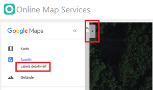
[[File:Hint.jpg]] Click on the upper left menu button in Google Maps to hide labels.<br> | |||
[[File:OnlineMapServicesLabel.png|300px]] | |||
[[File:Hint.jpg]] Please be aware, that there might be a small shift up to some meters with Google Maps Satellite images, even the map is geo-referenced. | |||
The reson for this shift is because we don't get the precise information for the resolution from Google. | |||
However, it is easy to correct with a one or two point move '''[[Background_Map#Adjust_a_Background_Map|(Adjust Background Map - F9)]]''' of the aerial photo background map. | |||
[[File:OnlineMapServicesBackgroundMap.png|600px]] | |||
===OpenStreetMap=== | |||
Available for all Coordinate Systems. | |||
[[File:OnlineMapServices OSM.png|600px]] | |||
===Swisstopo=== | |||
Available only for Swiss Corrdinate System LV95 (EPSG 2056) | |||
- swisstopo Orthophoto<br> | |||
- swisstopo Landeskarte<br> | |||
- swisstopo Amtliche Vermessung | |||
Revision as of 13:14, 24 February 2021
![]() This function does not work on some computers with 32-bit version of OCAD!
This function does not work on some computers with 32-bit version of OCAD!
Choose this command from the Background Map menu to load a screenshot from a Online Map Service as background map.
--> Short Video on YouTube
Define an extent
Click on the Update button to move to Online Map Service to the center of the drawing area.
Move and zoom until the Online Map Service has the desired extent. You can also enlarge the Online Map Services dialogue by clicking and dragging a corner. The image you see in the dialogue will be loaded as background map.
Load as backgorund map
Click Load as background map to load the image in the dialogue as background map. OCAD changes to Draft mode afterwards.
If the map is geo-referenced, your screenshots will also be geo-referenced and appear at the right spot.
Services
You can choose between the following Services:
Google Maps Satellite
Available for all Coordinate Systems.
![]() Click on the upper left menu button in Google Maps to hide labels.
Click on the upper left menu button in Google Maps to hide labels.

![]() Please be aware, that there might be a small shift up to some meters with Google Maps Satellite images, even the map is geo-referenced.
The reson for this shift is because we don't get the precise information for the resolution from Google.
However, it is easy to correct with a one or two point move (Adjust Background Map - F9) of the aerial photo background map.
Please be aware, that there might be a small shift up to some meters with Google Maps Satellite images, even the map is geo-referenced.
The reson for this shift is because we don't get the precise information for the resolution from Google.
However, it is easy to correct with a one or two point move (Adjust Background Map - F9) of the aerial photo background map.
OpenStreetMap
Available for all Coordinate Systems.
Swisstopo
Available only for Swiss Corrdinate System LV95 (EPSG 2056)
- swisstopo Orthophoto
- swisstopo Landeskarte
- swisstopo Amtliche Vermessung


