Magnetic Declination: Difference between revisions
Jump to navigation
Jump to search
No edit summary |
No edit summary |
||
| Line 4: | Line 4: | ||
*'''Magnetic declination''': The angle between the direction of the magnetic meridians and the direction to the geographic North Pole at the observation site. With uncertainty factor and expected change per year. | *'''Magnetic declination''': The angle between the direction of the magnetic meridians and the direction to the geographic North Pole at the observation site. With uncertainty factor and expected change per year. | ||
*'''Grid convergence''': The angle at the observation site between true north and grid north. | *'''Grid convergence''': The angle at the observation site between true north and grid north. | ||
*'''Grid magnetic angle''': The | *'''Grid magnetic angle''': The sum of the two values above, by how much the map should be rotated.<br> | ||
You can only '''Apply''' the Angle, if no objects have been drawn yet. If you have already drawn objects, use the '''[[Map_Transform#Rotate_Map_to_Magnetic_North|Rotate Map to Magnetic North]]''' function instead. | You can only '''Apply''' the Angle, if no objects have been drawn yet. If you have already drawn objects, use the '''[[Map_Transform#Rotate_Map_to_Magnetic_North|Rotate Map to Magnetic North]]''' function instead. | ||
Revision as of 11:58, 7 January 2019
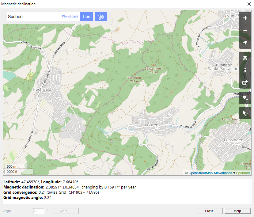
In the dialogue Magnetic Declination you can see the current Declination for your position. The function opens Open Street Map at your current position.
- Latitude/Longitude: Latitude and Longitude of your position.
- Magnetic declination: The angle between the direction of the magnetic meridians and the direction to the geographic North Pole at the observation site. With uncertainty factor and expected change per year.
- Grid convergence: The angle at the observation site between true north and grid north.
- Grid magnetic angle: The sum of the two values above, by how much the map should be rotated.
You can only Apply the Angle, if no objects have been drawn yet. If you have already drawn objects, use the Rotate Map to Magnetic North function instead.
![]() More information about Declination can be found in this Blog Post.
More information about Declination can be found in this Blog Post.
