Import GeoPackages: Difference between revisions
Jump to navigation
Jump to search
No edit summary |
No edit summary |
||
| Line 14: | Line 14: | ||
[[File:GeoPackageImport3.png]] | [[File:GeoPackageImport3.png]] | ||
=Example: Import Swiss Map Vector 10= | |||
*Download a GeoPackage dataset at https://www.swisstopo.admin.ch/en/geodata/maps/smv/smv10.html (e.g. SMV10_CHLV95LN02.gpkg) | |||
*In OCAD, go to menu '''[[Create_a_New_Map#Create_a_New_Map|File > New]]'''. Choose '''Topographic, city or leisure map''' as '''Map type''' and load the symbol set called ''SwissMapVector10_SymbolSet.ocd''. Choose '''Map scale''' 1:10'000. | |||
*Go to menu '''File >Import''' and choose the .gpkg file. | |||
*In our example, we do not import the text datasets.<br> | |||
[[File:SwissVector ImportGeoPackage.png]] | |||
*Select the ''Symbol'' field as Layer Information and load ''CH-SwissVectorMap 10000 to OCAD.ocdCrt'' as CRT file.<br> | |||
[[File:SwissVector LayerInformation.png]] | |||
*OCAD starts the import.<br> | |||
[[File:SwissVector Importing.png]] | |||
*Result in OCAD. Objects that has not been converted, will be loaded as unsymbolized objects.<br> | |||
[[File:SwissVector Result.png|656px]] | |||
*Hide or show unsymbolized objects in the '''Symbol''' menu with '''Show Objects without Symbol''' option.<br> | |||
:*To convert unsymbolized objects to a symbol, click on an unsymbolized object in the drawing area. You will see its name in the status bar in the lower left corner.<br> | |||
:*Select a symbol in the symbol box on the right side (e.g. symbol for chapel). <br> | |||
:*Go to menu '''Object > [[Change_Symbol|Change Symbol for all Objects with this Symbol]]'''<br> | |||
[[File:SwissVector ObjectsWithoutSymbol.png]] | |||
Revision as of 12:50, 8 August 2023
A GeoPackage (GPKG) is a data format for geographic information system implemented as a SQLite database container.
Choose the *.gpkg format in the file import dialog to import GeoPackages.
In the first dialog choose the datasets to import. By default, all datasets with data are selected.
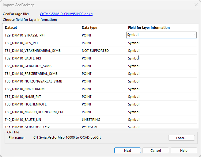
In the second you can choose the database for the layer information and a crt file to convert the imported objects to symbolized objects.
Example: Import Swiss Map Vector 10
- Download a GeoPackage dataset at https://www.swisstopo.admin.ch/en/geodata/maps/smv/smv10.html (e.g. SMV10_CHLV95LN02.gpkg)
- In OCAD, go to menu File > New. Choose Topographic, city or leisure map as Map type and load the symbol set called SwissMapVector10_SymbolSet.ocd. Choose Map scale 1:10'000.
- Go to menu File >Import and choose the .gpkg file.
- In our example, we do not import the text datasets.
- Select the Symbol field as Layer Information and load CH-SwissVectorMap 10000 to OCAD.ocdCrt as CRT file.
- OCAD starts the import.
- Result in OCAD. Objects that has not been converted, will be loaded as unsymbolized objects.
- Hide or show unsymbolized objects in the Symbol menu with Show Objects without Symbol option.
- To convert unsymbolized objects to a symbol, click on an unsymbolized object in the drawing area. You will see its name in the status bar in the lower left corner.
- Select a symbol in the symbol box on the right side (e.g. symbol for chapel).
- Go to menu Object > Change Symbol for all Objects with this Symbol
- To convert unsymbolized objects to a symbol, click on an unsymbolized object in the drawing area. You will see its name in the status bar in the lower left corner.


