Slide background

We do whatever it takes to make your maps perfect

Slide background
Slide background

OCAD – the powerful Swiss software application for Cartography and Orienteering.

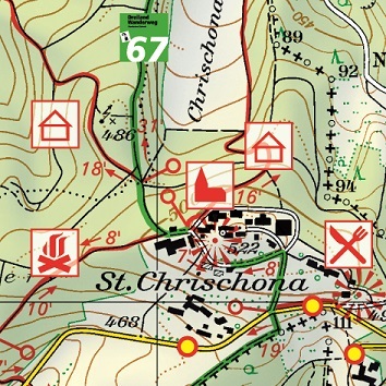
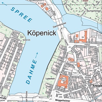
For creating and editing interactive and printed maps such as topographic maps, city maps and orienteering maps.

Available in 17 languages. Successfully used in the cartography, city and surveying offices, universities and orienteering clubs.

OCAD News

OCAD Route Analyzer 2.0 released

OCAD has enhanced its Route Analyzer and made it accessible to forest orienteering.OCAD Route Analyzer 2.0

OCAD Tutorials Updated

We have revised and updated our tutorials for course setting and orienteering map making.OCAD Tutorials

Discover the strengths of OCAD!

Choose cartography or orienteering by clicking on the respective picture.

Import Data

Use Existing Geo Data

Use existing and current spatial information data for your base map provided by national survey authorities or Open Street Map (OSM).

CaptureData

Capture and Derive Your Own Spatial Data

Enrich your map by capturing map features yourself using GPS, laser range finder and analyzing digital elevation models (DEM) or LiDAR data.

Drawing

Create Your Own Map Symbols

Assign your data to own created maps symbols. Use the unique drawing, editing and generalization tools to produce maps for the most demanding requirements in cartography.

Export Map

Print and Export Your Map

Finalize your map with a layout for printing, export for further digital use or create an interactive web map version.

MultipleRepresentation

Multiple Representation

Alter your map features in different representations without affecting your original map. However, if you change the original, the different representations will adopt these changes.

Thematik Mapper

Thematic Mapper

Visualize your statistical data with the Thematic Mapper. A step-by-step wizard assists you to get spatial overview of a specific theme or subject area.

LiDAR

Analyse Laser Scanning Data and Digital Elevation Models

The processing of LiDAR data and Digital Elevation Models is the heart of the OCAD Orienteering edition. Create contour lines, hill shading or vegetation maps in just one single step.

BestMapping

Prepare Existing Geodata for Mapping

In addition to LiDAR and DEM data, import cadastral surveying data, OSM data, display aerial photos or get information from Web Map Services (WMS), Google Maps or Google Street View.

Support

Capture Spatial Data with a Mobile Device

There are two ways to use OCAD in the field: The desktop version of OCAD runs on Windows Tablet PCs. In Addition, the OCAD Sketch App runs on mobile Android and iOS devices.

Drawing

Use the Sophisticated Cartographic Drawing and Editing Tools

Benefit from a large number of functions, which makes drawing and editing more easy and accurate. Use the latest International Specification for Orienteering Maps (ISOM) symbol sets for drawing and convert old maps to the new ISOM standards.

FinishWork

Finalize Your Map with a Layout

Finalize your map with a layout layer, which allows you to add peripheral information to a map. Export your map to one of the many formats for printing or further use.

CourseSetting

Set Orienteering Courses

OCAD provides completely integrated functions for course setting in orienteering, from simple courses to complex relay projects.

#1 Cutting-Edge Cartography Tools
Due to the regular and free updates of the subscription model, you will immediately benefit from OCAD’s latest cartography tools to streamline your map production. Your OCAD is always up equipped with the latest technology and standards. OCAD Timeline.

#2 Easier planning – Attractive Subscription Prices
With the subscription pricing, the entire product portfolio OCAD offers an easy entry to the latest technology. At a fair price point, you will get the proven quality of OCAD software and support. Moreover, you gain new functionality even faster than before. Details on terms and the pricing can be found in our Frequently Asked Questions (FAQ) here.                                    

#3 Efficient and Carefree Team Work
Thanks to the subscription option “OCAD for Teams” you can transfer your license to others immediately. If you synchronize your OCAD file and installation with a cloud service (e. g. Dropbox, OneDrive etc.) you avoid compatibility problems between different OCAD versions, files and functionality. Everybody involved works with the same and most current version.               

#4 Comfortable License Management
With the OCAD License Manager you can create organisations and add team members. This way, you always have an overview of whether and what kind of license your members currently have (subscription team license, subscription single user license, license of earlier OCAD versions). Team licenses can be automatically transferred to a member.                 

#5 Support by OCAD Experts
Do you have any questions about software or license management? Get technical support from OCAD experts with the subscription model. As an OCAD user, you will have access to numerous tutorial videos and extensive learning aids, such as the OCAD Wiki and tutorials. This allows for the optimal use of OCAD at any time.                                                                                  

#6 OCAD Viewer
The free OCAD Viewer is installed with every OCAD edition. With it you can continue opening and printing your map files even after your subscription period has expired.                                                                                                                                                                                                                                                                                                                                                                                                 

OCAD Editions –  Cartography and Orienteering 

Choose between:
Cartography
Mapping Solution
For use in professional cartography to create city maps, topographic maps and thematic maps.
arrow_forwardmore
500.- CHF / Year *
  • *All prices excluding VAT.
Cartography
Mapping Solution
For use in professional cartography to create city maps, topographic maps and thematic maps.
arrow_forwardmore
420.- CHF / Year *
  • *All prices excluding VAT.
Orienteering
Orienteering
Perfect to produce Orienteering Maps.
arrow_forwardmore
150.- CHF / Year *
Orienteering
Orienteering
Perfect to produce Orienteering Maps.
arrow_forwardmore
130.- CHF / Year *
Orienteering
Starter
Suitable for Starting with Cartography. Including Course Setting Module.
arrow_forwardmore
75.- CHF / Year *
Orienteering
Starter
Suitable for Starting with Cartography. Including Course Setting Module.
arrow_forwardmore
65.- CHF / Year *
Orienteering
Course Setting
For Course Planning in Orienteering Sport.
arrow_forwardmore
30.- CHF / Year *
Orienteering
Course Setting
For Course Planning in Orienteering Sport.
arrow_forwardmore
30.- CHF / Year *

OCAD Trial

Try OCAD Full Version.
Please register to request the free trial version.

OCAD Sketch App

The OCAD Sketch App is designed for mapping in the field on mobile Android and iOS devices. Download and use of the app is free of charge.

OCAD Viewer

With the free OCAD Viewer you can open, save, print and export OCAD files. Also, you can show and hide map symbols.

© OCAD AG 2023